
On This Page
When teams search for sandbox simulation fire rain wind, they are looking for an interactive terrain model that reacts in real time, not a static map. ASFAN's GIS sandbox simulation does exactly that inside a three-wall immersive room, letting planners, trainers, and decision-makers watch fire spread, rainfall, and wind behavior over real terrain data.
See the GIS Sandbox Simulation Platform
This short video shows how terrain, fire, rain, and wind simulation modes work inside ASFAN's immersive GIS room.
What sandbox simulation fire rain wind means
Sandbox simulation fire rain wind describes an interactive GIS terrain mode — whether on an AR sandbox table or inside an immersive room — where imported or scanned terrain reacts to fire, rainfall, and wind inputs in real time. Instead of a static map, planners and trainees see how ignition points spread, how water drains or pools, and how wind carries pollution across the same terrain model.
ASFAN builds this capability into its GIS and Immersive Content for Operational Digital Twins platform, combining three large-format projection walls with GeoTIFF terrain import and real-time simulation controls.
Fire, rain & wind simulation modes explained
The sandbox simulation platform includes four core modes:
- Fire & Wildfire Simulation: models ignition and spread using terrain type, spread strength, wind speed, and wind direction.
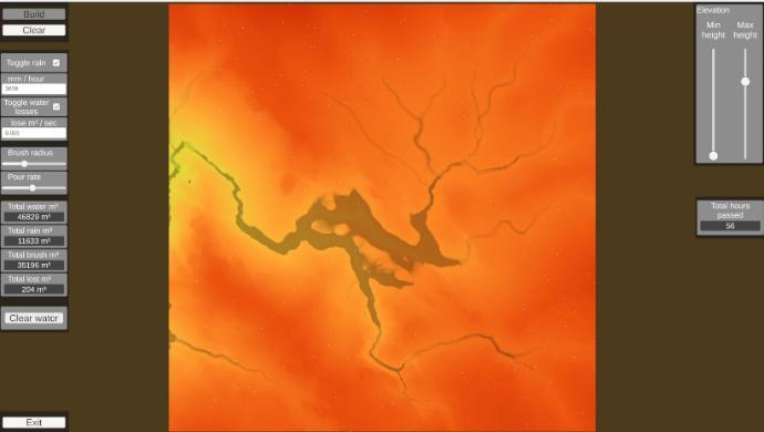
- Water & Rain Simulation: simulates rainfall, water flow, drainage, absorption, and manual water placement across terrain.
- Wind & Pollution Simulation: controls wind speed, direction, and altitude while injecting pollution sources to observe dispersion.
- Sandbox Data Preview: lets teams preview imported terrain data and fine-tune elevation rendering before running a scenario.
Why teams use this sandbox simulation
Sandbox simulation fire rain wind is used for:
- Emergency preparedness and disaster response planning.
- Environmental risk review and watershed planning.
- Research and training built on realistic terrain scenarios.
- Interactive briefings for decision-makers and government teams.
FAQ About Sandbox Simulation Fire Rain Wind
What is sandbox simulation for fire, rain, and wind?
It is an interactive GIS terrain mode inside ASFAN's immersive room that models fire spread, rainfall and water flow, and wind and pollution dispersion over real or imported terrain data in real time.
How does the fire, rain, and wind sandbox simulation work?
Teams import terrain or GeoTIFF data, then switch between simulation modes to control ignition points, spread strength, wind speed and direction, rainfall intensity, and pollution sources while results are projected across three synchronized walls.
Where can I see ASFAN's full GIS sandbox simulation platform?
Visit ASFAN's GIS and Immersive Content for Operational Digital Twins page to review every simulation mode and the how-it-works workflow.
Client & Visitor Reviews
Share your experience, feedback, or opinion about this page content.
Write a Review
Latest Reviews